Afar Geo-Toursim Destination sites
Explore Tourist Sites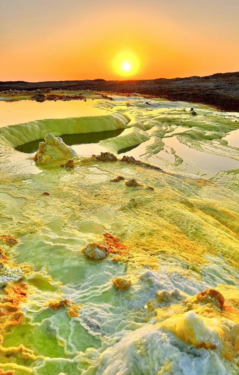
The dynamic natural landscape, with its diversified colors and morphologies (i.e., naturally sculpte...
The dynamic natural landscape, with its diversified colors and morphologies (i.e., naturally sculpted salt canyons, mushrooms, ropy structures, salt flowers, and various brine pools, acidic hot springs, and fumaroles), makes Dollol one of the world's wonders. The dynamic geological processes that continue to shape the landscape, combined with the diverse raw materials, create colorful landscapes. The Dallol Depression is situated in the northern part of the Afar Depression (about 320 km north of Samara, the capital city of Afar Regional State, Ethiopia), where the East African Continent is slowly splitting apart and where a new ocean will form in the future.
Read MoreLocal Area: Ahmed Ella
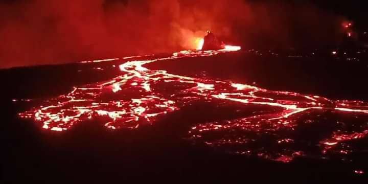
The Erta Ale volcano is located in the Northern Afar Depression, northeastern Ethiopia. It is a bas...
The Erta Ale volcano is located in the Northern Afar Depression, northeastern Ethiopia. It is a basaltic shield volcano characterized by an elliptical caldera, elongated NNW-SSE (1,600 x 700 m). The caldera has been hosting two active pit craters or persistent lava lakes since at least 1967 (French and Italian geologists) or possibly since 1906 (visitors) (e.g., Pastori, 1906; Dainelli and Marinelli, 1907; Nesbitt, 1935; Barberi and Varet, 1970; Varet, 2018). This makes Erta’ Ale the longest-lived lava lake in the world. Erta Ale volcano is changeable, unpredictable, and one of the most stunning volcanoes in the Horn of Africa.
Read MoreLocal Area: Afdera
.jpg)
The two geothermal areas are characterized by hot spring pools (ranges 77-990C), fumaroles and small...
The two geothermal areas are characterized by hot spring pools (ranges 77-990C), fumaroles and small craters of hot mud with pulsating nature (Fig. xx). The pools are unbelievably deep and filled with hot, steaming water. The hot spring pools are characterized by spectacular green, sky blue, and yellow colors, and the colour variation is due to the different mineral contents. At places there are geysers (often about 0.5-6m tall), steaming, fragile and altered grounds, and the presence of elements like micro-organisms (Figxx). These hot springs are dominantly bicarbonate waters, with NaHCO3 composition, and a relatively high pH (9) is recorded in Allalobad. Allalobad is located in Central Afar, approximately 21km south of Samara, the capital city of Afar Regional State, and is situated along the axis of the Tendaho Graben, which runs in a NW-SE direction at the base of the mountain. Tio is another geothermal field located in the foothills of the Tendahoo Mountain range in the Central Afar Depression, southwest of Allalobad, and approximately 20 km east of Aydaytu Town.
Read MoreLocal Area: Dupti
.jpg)
Boina is a flat elliptical Fumaroles area near the summit of Dabbahu (661564N &1399202 E and about 2...
Boina is a flat elliptical Fumaroles area near the summit of Dabbahu (661564N &1399202 E and about 2km NE of the summit). Many pits/craters with fumarole activity (locally known as “Boina”) have been observed, and the less active fumaroles have been adapted by the local people to condense (using rocks, grass, and woods) drinking water (figxyz). Fumaroles (with sulfur degassing and stains on the ground) have also been noticed with prominent fissures on the northwest sides of the craters, which are roughly oriented NW-SE. Fumaroles, along with fissure systems and inferred calderas in Boina, make the area a tourist destination of international value.
Read MoreLocal Area: Teru
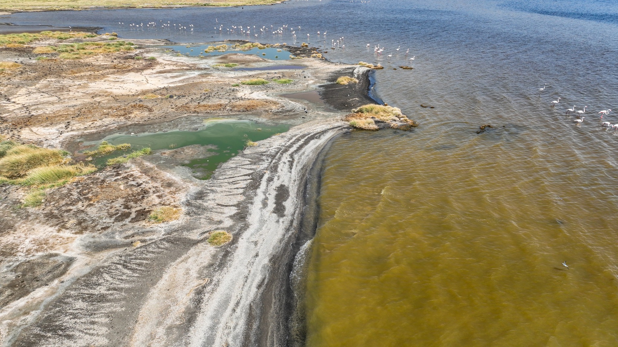
The ultimate destiny of Awash River morphology, its hot springs, proximity to the spectacular Dama A...
The ultimate destiny of Awash River morphology, its hot springs, proximity to the spectacular Dama Ale Volcano, and being an intersection point of the three rifts make Lake Abhe one of the most fascinating areas, with considerable aesthetic, scientific, and economic value. The sunset activities and colonies of flamingos are also other astonishing aspects of the area (figxyz). Apart from its beauty, Abhe Lake offers adventure tourism activities such as trekking and boat riding.
Read MoreLocal Area: Afambo
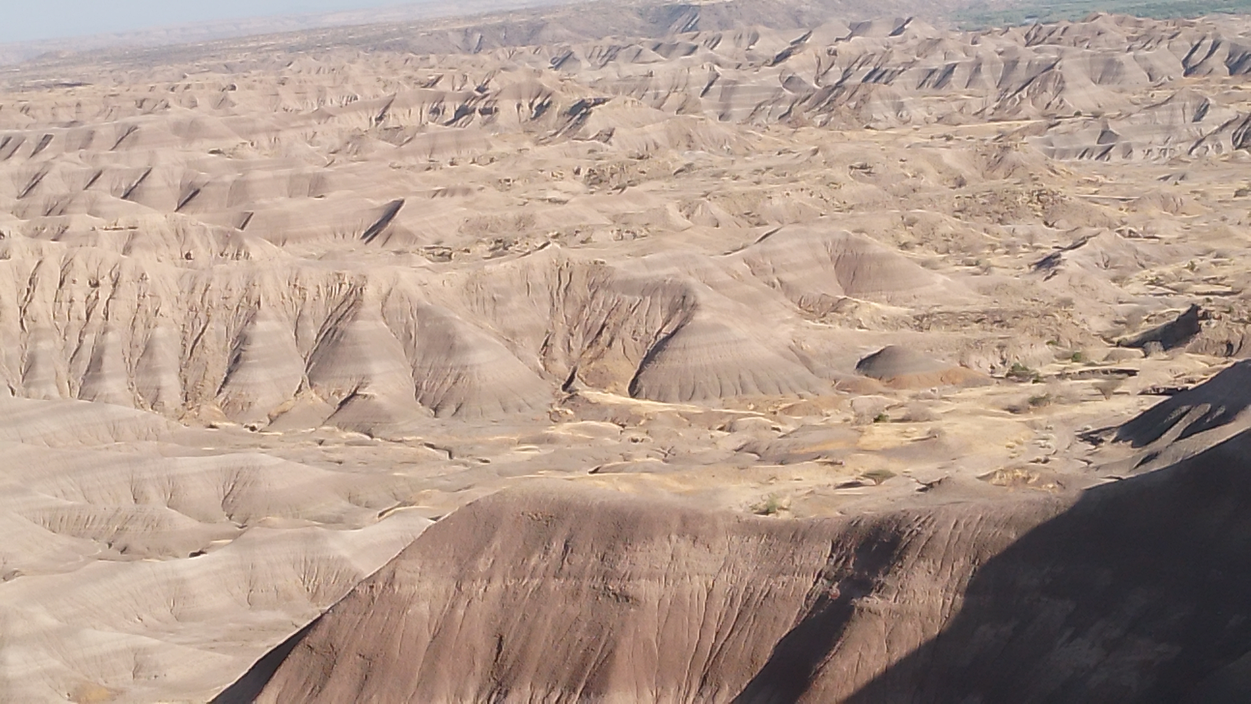
The archaeological sites, such as Adda A’r localities, are situated in a unique tectonic and volca...
The archaeological sites, such as Adda A’r localities, are situated in a unique tectonic and volcanic transition zone between the Main Ethiopian Rift (MER) and the Afar Rift. Sediments along the western Afar Rift margin in the lower Awash provide an exceptional window into the origins of hominids. The Adda A’r/Hadar area is characterized by its cyclically arranged fluviatile and lacustrine deposits (i.e., bentonites and detrital materials) intercalated with tuff horizons, basalt flows, and overlain by Quaternary sediments. The area is known for its rich hominid content (3.5 million years ago; Australopithecus ramidus, also known as Lucy) and mammal faunas.
Read MoreLocal Area: Adda A’r/Hadar
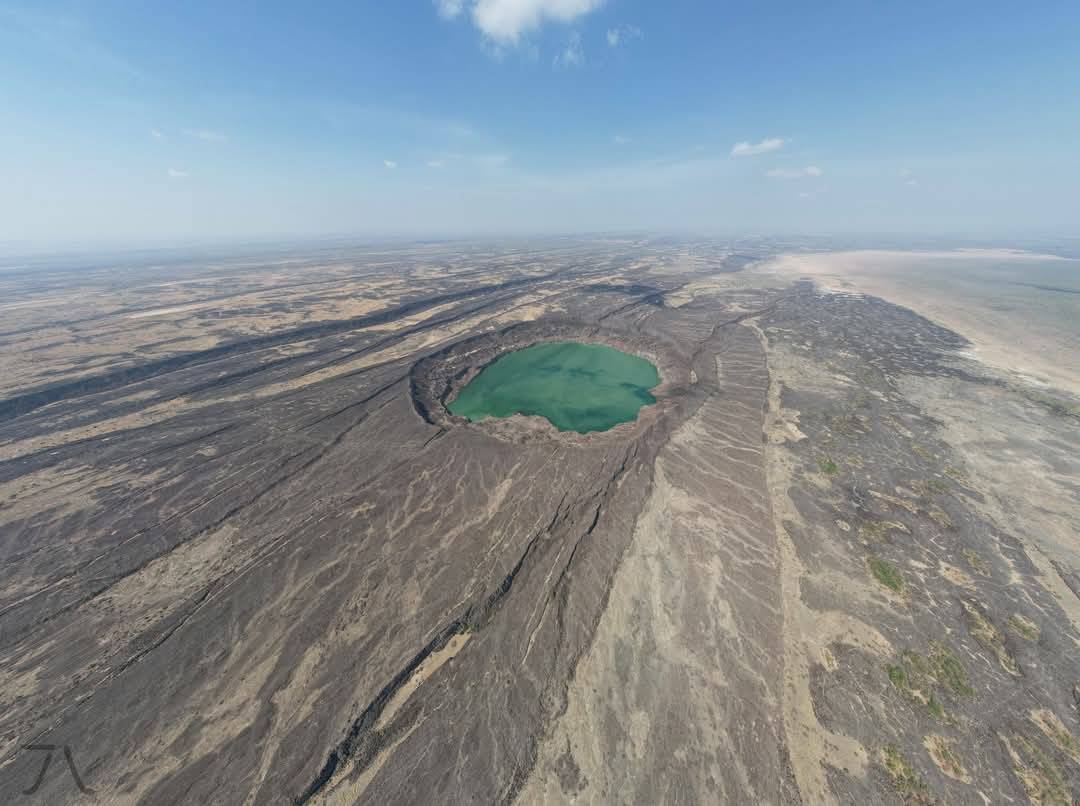
An impressive volcano-tectonic Loma Lakes are found within the Manda Harro Axial Range of the Centra...
An impressive volcano-tectonic Loma Lakes are found within the Manda Harro Axial Range of the Central Afar Depression, north of Samara, the capital city of Afar Regional State, in the Tendaho Graben. They are situated approximately 5-6 km north and northeast of the Samara Industrial Park and are accessed by unpaved dirt roads. It is an oval-shaped crater aligned along the NNW emissive fissures and surrounded by basaltic and pyroclastic materials. The lake water is fed by hydrothermal waters, and the color of the lake water is uncomely, ranging from red to green.
Read MoreLocal Area: Samara

Awash Waterfalls are controlled by lithological (e.g., alternating strata of basalt with varying str...
Awash Waterfalls are controlled by lithological (e.g., alternating strata of basalt with varying strengths and ignimbrite), structural (i.e., a normal fault (NNE) and various sets of joints), and geomorphological factors, such as weathering and erosion. Based on aesthetic values such as scenery, the side spreads water with various steps, gorges, sounds of the falls, and views of crocodiles on the riverbank, providing a wonderful experience and leaving lasting memories for visitors.
Read MoreLocal Area: Awash
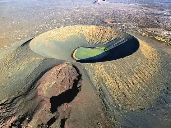
One of the prominent hyaloclastite volcanoes (known as Catherine volcano, or locally Dora Lea fig xx...
One of the prominent hyaloclastite volcanoes (known as Catherine volcano, or locally Dora Lea fig xxx) is located on the Dallol Depression near Karum Brine Lake. The hyaloclastite ring has a diameter of approximately 250 m and a height of about 90 m, with some brine water present at its center. The source of the water could be underground seepage from the nearby Karum lake or geothermal water.
Read MoreLocal Area: Afdera